Cudlee Creek, South Australia, Australia

A little history of Cudlee Creek and the upper reaches of the Torrens Gorge in the Adelaide Hills.

This site is dedicated to the family of Peg & Bill Chartres
(Nick, Wayne, Graham, Jason and their families),
so as they have a
better understanding of their heritage.
Peg's g-g-grandfather, George Banks, first settled in The Prairie, Cudlee Creek, in the
early 1850's.
George purchased "Walnut Grove", Hollands Creek in 1857 when he married Mary Ann Farnham.
(Two of George's brothers, William and Edward, also acquired holdings in the Cudlee
Creek District).
Peg's g-grandfather, Cain Thomas Banks (known as Thomas),
purchased "Woodlands"
(on what is now known as Banks Road, Cudlee Creek) in 1891.
"Woodlands" is the property that Peg grew up on.
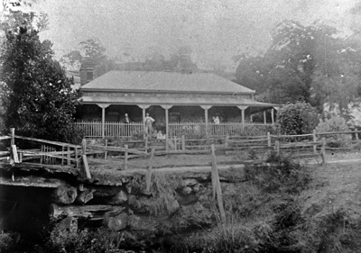
"Walnut Grove"
George and Mary Banks, with their children,
Hollands Creek, Cudlee Creek, SA.
(Photo Peg & Bill Chartres' collection Circa 1870)
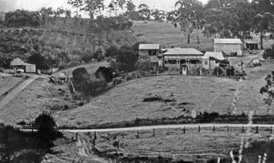
"Woodlands"
Home of Thomas and Phoebe Banks,
Banks Road, Cudlee Creek, SA.
(Photo Peg & Bill Chartres' collection Circa early 1900's)
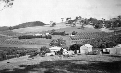
"Woodlands"
Home of Bill & Olive Menz,
Banks Road, Cudlee Creek, SA.
This photo was taken from the home of Keith Menz
(Peg's father), which was located on the northern
boundary of "Woodlands")
(Photo Peg & Bill Chartres' collection Circa 1940's)
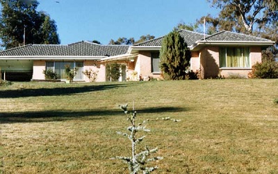
The home of Peg & Bill Chartres
Gorge Road, Cudlee Creek.
(Photo Peg & Bill Chartres' collection Circa 1978)
CUDLEE CREEK, S.A., AUSTRALIA

Cudlee Creek is derived from the Aboriginal Kaurna or Peramangk word "Coodla" meaning Wild Dog
(Dingo), hence Cudlee Creek means "Wild Dog" Creek.
The township is located on Gorge Road, in the beautiful Torrens Gorge about 28 kilometres
from Adelaide
(via Athelstone and the Gorge Road).
The ABS 2016 census records 421 people living in Cudlee Creek.
(a decrease of 52 since the 2011 census)
The District of Cudlee Creek is bounded by, Paracombe in the north, Lobethal in the south,
Gumeracha in the east and Castambul to the west;
it includes the local areas of Cudlee Creek, Fox’s Creek, Hollands Creek,
Millbrook, The Prairie and Chain of Ponds.
The area was first settled by William Kelly, his wife and baby daughter,
(Kelly is believed to have been
the first white man to have visited the area),
they arrived in Adelaide in December 1838, and settled at Cudlee Creek a few months later
(late 1839 early 1840).
The early pioneer families include the Kelly’s, Fox’s, Hannaford’s, Redden’s, Farnham’s,
Bank’s, Wakefield’s, Dennis’, McNamara’s,
Kennings’, Ludewigs’,
Dickson’s, Schlein’s, Tippett’s, Pool’s, Barty’s, Minogue’s, Lambert’s, Crouch’s, Hoad’s,
Curtis’ and Hatchard’s.
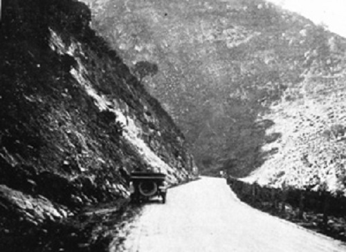
"If an unlabelled moving picture of the Gorge road were town on the screen people would ask where it was. The route is an eye-opener in rugged beauty. For most of the 17 miles, from the time the gateway is entered at Athelstone, the track runs between massive, rock-ribbed, tree-spread cliffs which climb hundreds of feet, and seem to meet the blue sky. From the moment you get into contact with the great panorama, it is a wonderland of wild, decorative effects, carried out by Nature to big scale. The road has the appearance of a bold, tiny interloper, twisting in and out among the boulders with flimsy, and almost precarious, audacity. Looking up on one side you see the hills, mottled by shadows on a sunny afternoon, lean their grey bulk against a radiant back ground. On the other the jagged, broken rock offers, at times, a rather uncomfortable proximity, supplying a striking colour contrast with their red and dark blue and brown faces. Running along this 24-ft. thoroughfare, amid some of the most impressive open-air sculpture to be seen in Australia, you involuntarily duck now and then, in expectation of being hit by one of these giant fists. Then, right underneath, flows with placid grace, the little creek, framed in brilliant green rushes or tender fern. When the towering avenues disappear, as it were, into the wings of this magnificent stage, there come tough the scattered gums glimpses of fruit gardens, designed as symmetrically as a draught board, or arranged in marvellous rows of potato and tomato plants, suggesting the faultless elegance of the top lines in a copy book. So you get on this excursion up the Gorge road, the blend of dainty, man-made utilities and the moving grandeur of God-made scenery."
The Register (Adelaide, SA.) 20 January 1922
"PICTURES ON THE GORGE ROAD."
IT WAS DIFFICULT FOR THE EARLY PIONEERS OF CUDLEE CREEK TO GET
INTO AND OUT OF THE DISTRICT
"Several parties have bitterly complained to us of the impassable state of the road between
Adelaide and the Reedy Creek mine, by the Chain of Ponds. A gig was stuck in the centre of
the road last Friday, and the driver, a Mr East, was unable to extricate it without the
assistance of several passing travellers. This is the more felt as there is a mail just
established on that route, and unless something is done for its improvement it will be utterly
impossible for the carriers to accomplish their journeys within the prescribed period. Besides
this consideration there is a largely increased traffic on that road now, and it is high
time for the Government to adopt some measure to facilitate the communication between that
populous part of the country and the metropolis.”
Adelaide Times, 16 October 1848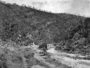
An early photo showing the track to Cudlee Creek along the bed of the River Torrens.
(Photo Circa 1870 - slsa B 1885)
This track could only be used when the Torrens was not flowing!
The early pioneers of the Cudlee Creek District endured much hardship, not only to establish
their holdings, but also to get into
and out of the district as there were no roads or bridges and the tracks had to cross the
river bed.
Prior to the construction of the Gorge Road, Cudlee Creek was initially reached along the
bed of the River Torrens
(when it was not flowing), and later, after the North East Road was opened
in the 1870's, via Tea Tree Gully or Anstey's Hill all of which were extremely difficult
journeys.
Many articles appeared in the local newspapers describing the difficulties and
displeasure of the early pioneers.
“...In 1853, he [Alfred Hardy, 18 March 1863, Supervising Surveyor for the North-Eastern district] said, there had been only ten miles of metalled road between Adelaide and the O.G. public house. The remainder of the track to Gumeracha was part swamp where drays could be bogged for the whole winter. A horseman, by using “the greatest exertion would take from morning to night to reach Gumeracha, and then he thought himself lucky if he arrived there without accident. With the improvements and a metalled road all the way, the same journey could be comfortably accomplished in four hours. When the road was completed to Blumberg in the following year, he said, there would only be 25 miles left to Mannum...”
(Bill Stacy, 1982, Highway South Australia, October, Highways Department, Adelaide)
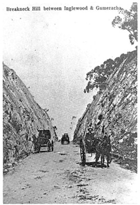
“... setting forth the bad state of the above road. It stated that drays sent especially to Gumeracha some time since had been compelled to return empty, and that even horse teams had been unable to get further than Breakneck Hill.”
Adelaide Observer, 1 July 1854
“... If they wished to continue the increase of their exports of wheat and flour, they must devise some improvement in the present system of road-making. ... At nearly every meeting on the subject of roads, held during the last five or six years ... the Central Road Board had been universally held up to opprobrium. And he had only to refer to the vacillation and want of system displayed, by the Board in the management of their own North-Eastern -road to prove their utter incapacity. In the first instance they refused to recognise it as a main road. After they had declared it to be a main line, they resolved that it should go by way of the Teatree Gully. They subsequently agreed to reopen the question, received memorials and counter memorials, deputations, &c., and at last their united wisdom brought them to the conclusion that two main lines of road were required — one leaving Adelaide by Bailey’s Garden, Paradise, and Anstey’s Hill; and the other by the Company’s Mill, tough the Tea Tree Gully. Both of these roads were then united about 12 or 13 miles from the starting point. Thus the money voted for the North-Eastern-road had been so divided as to make two bad roads, instead of one good one. ...”
SA Register, 5 August 1857
Blyth's Cutting, Breakneck Hill, Inglewood
Photos - LHS slsa B 62350 - RHS Torrens Vally Historical Journals - Circa 1875
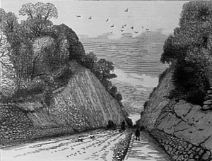
"The triple ceremony of opening the Breakneck Hill cutting, and the two new bridges at Inglewood and Chain of Ponds, was celebrated on Wednesday, 18th March. The occasion was looked forward to with intense interest by the residents along the North-Eastern-road, and it will not be soon forgotten by them, as on it they witnessed the full realization of all the hopes they had cherished for many years past. Breakneck Hill has long been a hill of difficulty to those settlers who were obliged to surmount it on their way to Adelaide. Double teams had to be brought into requisition to take a small load to the summit, but this was not the only inconvenience. The gradients were so steep, and a curve in the road so abrupt, that it was positively dangerous to descend the hill and not a few accidents have ended in making the attempt — hence the character name by which the mount is most generally known. It cannot, therefore, be wondered at that the people interested should watch with great anxiety the progress of a work which was to obviate all the difficulties they had to contend with, and should assemble with glad and grateful hearts to commemorate the accomplishment of that work. The morn dawned gloomily, portending rain, but before noon the threatening appearance had vanished, and although the sun only exhibited his smiling face at intervals, yet the day was pleasantly fine throughout.
South Australian Chronicle March 23rd 1863
In 1851 the government decided that two "main" roads should be constructed,
(which would converge at Houghton),
to service the upper reaches of the Torrens Valley, one via Anstey's Hill
(Lower North East Road)
,
the other via tea Tree Gully (Main North East Road), to
the Gumeracha
Bridge, from where it would continue to Stony Creek (Torrens Valley
Road).
This route was approved by the Central Road Board in July 1853.
The Gumeracha Bridge was opened on 5th February 1858 by Miss Esther Kelly, (the first resident European female born in the district), after which (Not before!) it was subjected to a load test.
…The members and officers of the Board proceeded then to test the deflection. The bridge was subjected to a pressure of between 30 and 40 tons, being covered with dray-loads of sand, and every vacant space covered up with horsemen or bullock teams. The result was its yielding only one-sixteenth part of an inch. We believe this to be a most unusual instance of strength and solidity. …
The South Australian Register - Monday February 8th 1858)

More than 50 years after the first settlement the residents of the Cudlee Creek District were still seeking easier access to the area
The people of the Upper Torrens Valley, disheartened by their isolation, began a campaign to enlist
the governments support to
provide access to their area.
In 1912 they lobbied for a railway line to be constructed along the banks of the River Torrens.
“The residents are now fully alive to the fact that a railway must come direct from the city to part of the Torrens Valley, and at a not far distant date. The main road to the city is in some places almost impassable for vehicles with heavy loads. Nearly 100,000 cases of export apples will be sent away from the district this season, and many more would be forwarded if only they could be landed at Port Adelaide by a cheaper and more modern means of transit.”
“Torrens Valley Railway”, Mount Barker Courier, 22 March 1912.
The request, however, was unsuccessful, but, at about the same time, the people of Castambul succeeded
in their request to have
a road [Gorge Road] built along the banks of the River Torrens
from the Torrens Weir at
Athelstone to Castambul, which including a bridge over Sixth Creek, was completed by January 1914.
This led to a campaign to have the Gorge Road extended to connect with the Main North East Road at
the Gumeracha Bridge Cudlee Creek.
This campaign was helped by the government’s decision to build a reservoir at Millbrook.
The road between Castambul and Gumeracha was begun in 1915, but was suspended in 1916 due to the war
effort. Construction
was resumed in 1919 and the road opened in November 1921. However the Metalling
(The Latin for a mine or quarry is metallum; so the material from a quarry used for road building
is called “metal”) was not completed until 1924 .
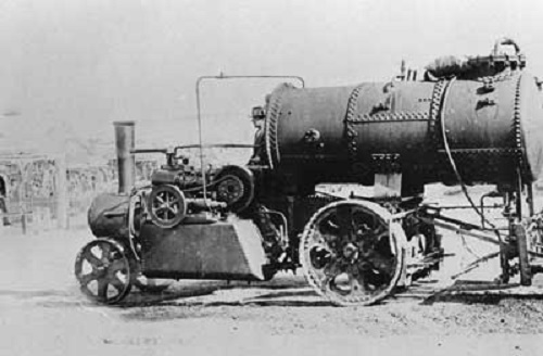
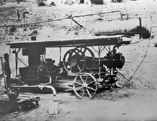
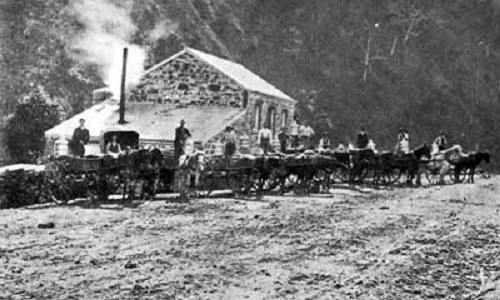
'Mann' steam wagon and tar sprayer
used during the construction of the
Torrens Gorge Road.
(Photo slsa B-62352 c1922 )
Construction Crew
working on the Gorge Road.
(Photo Peg & Bill Chartres' collection - Circa 1923 )
A steam engine and compressor
used during the construction
of the Gorge Road.
(Photo Photo The State Library of South Australia Circa 1920 - slsa )
Crusher at Tea Tree Gully,
similar to those used
on the Gorge Road.
(Photo Circa 1915 Source 4th S.A.Engineering Heritage Conference
15th May 2015)
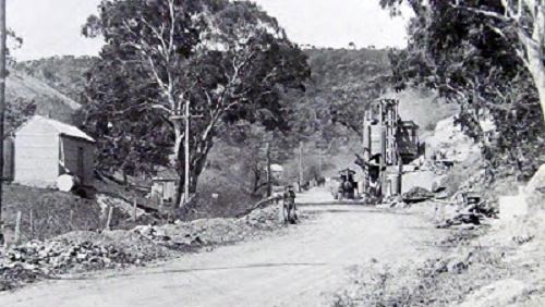
Gorge Road 1924.
(Photo Peg & Bill Chartres' collection - Circa 1924)
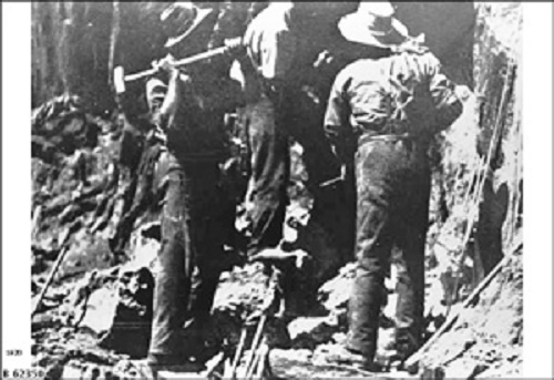
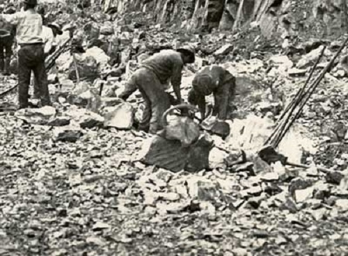
Construction workers
drilling 'shot holes' by hand
using sledge hammers during
the construction of the
Torrens Gorge Road
(Photo Photo The State Library of South Australia
Circa 1923 - slsa B62350)
“The construction of this highway was authorised about eight years ago in order to alleviate the position of producers in the Gumeracha districts en route, who are not served by a railway, and, as far as can be seen at present, must depend upon road carriage. The old Gumeracha-road climbs 1,400 ft. with grades of 1 in 8 and 1 in 10. Produce carried on it must be hauled over tee high hills, of which Anstey’s Hill is perhaps the best known. This must have for many years been a severe handicap to gardeners and others who had to market what their land produced. The new road is such a vastly different proposition, however, that although it is still practically little better than when the track was hewn out of the hillside — for the metalling has only just begun — it is already preferred by the market gardeners to the old road. When it is finished it will be a boon. ...
Chronicle (Adelaide) 28th January 1922
"...Eventually there will be a stretch of 17 miles from Athelstone to the Gumeracha Bridge with a gradient of no more than 1 in 25 — a gentle rise of a thousand feet compared with tee bad hills rising 1,400 ft. … The roadway is 24 ft. wide, and for a long distance the main pipe line from Millbrook Reservoir is laid in a channel at one side. There are five concrete bridges in the total length, for the road crosses the river five times — it follows the course of the stream for 14 miles. These bridges have excited the admiration of engineers all over the Commonwealth and are a triumph for Mr. Fleming. They are all concrete arch structures, on the cantilever principle, the longest span being 102 ft. They are beautiful bridges and practically everlasting. One of the features is the concrete parapet on each side, which is of graceful design. The successive bridges from west to east are named Bachelor’s, Crouch’s, Hoad’s, Union, and Monfries’, four of them being named after old settlers on nearby holdings. In one place, in order to avoid cutting away a cliff, a concrete overhang, 200 ft. long, was constructed. In this way the ingenuity of the engineer saved an expenditure of about £3,000. …”
Conicle (Adelaide), 28 January 1922
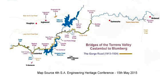
Bridges of the Torrens Valley - Castambul to Blumberg (Birdwood)
The lobbying of the residents of the upper reaches of the Torrens Valley, combined with the government’s decision
to build reservoirs at Millbrook and Mount Crawford, plus the fact that motor vehicles were experiencing
difficulties in negotiating the steep grades of the Main North East Road forced the government to agree to
construct the Gorge Road from Athelstone to the Gumeracha Bridge.
This was the largest undertaking ever attempted in South Australia.
The first section, of about ten miles (16 kilometres), from the weir
at Athelstone to Castambul, included a simple bridge across Sixth Creek (The Corkscrew)
was completed in December 1913.
“What will certainly become one of the “show” routes in the ranges is the new road tough the Torrens Gorge ... recently completed by the Government ... a pleasing drive of tee miles along the southern bank of the Torrens brings one to the junction of two district roads. Already the gardeners and others in the neighbourhood of Montacute and Castambul, and beyond, have taken advantage of the regular and easy gradients the Gorge-road offers. The Corkscrew leading to the Sixth Creek-road has been abandoned by all who could make use of the new track.
Advertiser, 17 January 1914
The final section, between Castambul and the Gumeracha Bridge, was begun in 1915 to relieve unemployment and was finally completed in 1924.
The Government are anxious to put in hand as quickly as possible work to relieve unemployment. The Commissioner of Crown Lands (Hon. G. Goode), who has control of the Roads Department, stated on Monday that during the next week or two work would be started on the new Torrens Gorge Road, absorbing from 650 to 700 men.
Advertiser, 11 May 1915
THE ROAD BRIDGES OF THE TORRENS VALLEY AREA
CUDLEE CREEK, S.A., AUSTRALIA
The first road bridge built in the district was a timber bridge at Inglewood in 1851; this was replaced with a
masonry arch bridge in 1863.
The first bridge across the upper reaches of the River Torrens was the Gumeracha Bridge in 1858, this was a
laminated timber arch bridge which was upgraded to a steel arch on the same abutments in 1887.
In 1861 a laminated timber arch bridge was constructed at Blumberg (Birdwood)
which was replaced with a concrete encased steel arch bridge in 1915.
The Sunning Hill Bridge (now submerged below the Millbrook Reservoir) was built
across the Chain of Ponds Creek in 1863.
The original Chain of Ponds Bridge, on the North East Road, was a reinforced concrete construction built in 1917
and was replaced by the current bridge when the North East Road was realigned in 1999.
Prior to the construction of bridges the River Torrens could only be crossed by fording the dried up or slow
flowing river, which became a very dangerous and difficult exercise as the flow of the river increased. Before
road bridges were built some foot bridges had been constructed, but they also were subject to the flow of the
river, and were often impassable, and sometimes even washed away by the flooded river.
The wooden construction Union Bridge, built in 1871, was the first bridge built on what is now known as the
Gorge Road. This was replaced during the construction of the Gorge Road by a steel arched, concrete encased bridge
(also called the Union Bridge) in 1917.
The Prairie Bridge, a timber deck on
riveted steel girders, was built across the River Torrens (1909) at the bottom of Prairie Road to provide access
to Paracombe via Torrens Hill Road (known locally as “Billy Goat Hill” because of its steep
winding nature), this was prior to Torrens Hill Road being realigned to remove some very sharp and dangerous
bends which had caused vehicles to plunge into the River Torrens below resulting in injury and even death.
During the construction of the original Gorge Road (1912-1925) six bridges were built across the River Torrens and
a concrete deck on concrete piers, called The Cantilever (although it was not actually a cantilever)
was cut into the side of the steep wall of the Torrens Gorge.
Sunning Hill Bridge, Millbrook
A laminated timber arch bridge built in 1863.
Now submerged under the Millbrook Reservoir..
Photo slsa B9146 Circa 1880
The Inglewood Bridge - North East Road
The first road bridge to be built in the area in 1851 was a wooden structure.
This was replaced by the current bridge (above) in 1863 which is a masonry arch bridge,
and is still in use.
According to Bill Stacy, this is probably the oldest structure in
South Australia still carrying main road traffic.
Photo Highway Magazine Circa 1982
The original Chain of Ponds Bridge (North east Road), built in 1917,
of reinforced concrete .
This bridge was replaced in 1999.
Photo slsa PRG 280/1/9/295 Circa 1916
The original Gumeracha Bridge (North East Road), (laminated timber arch),
was opened on 8/02/1858.
Photo shows the original timber arches
(which were replaced with steel 1872)
propped up with timber!
Photo slsa B72166/43 Circa 1870
Chain of Ponds Bridge,
a reinforced concrete girder bridge built in 1917
as the Millbrook Reservoir fills for the first time.
(Replaced with a new bridge of concrete slab on steel
girders construction in 1999)
Photo slsa B4400 Circa 1918
"New" Gumeracha Bridge,
with new iron frame work (1887) (on the original Abutments)
and a new concrete deck (1987), is still in use.
Photo Gumeracha District History Centre Circa 1987
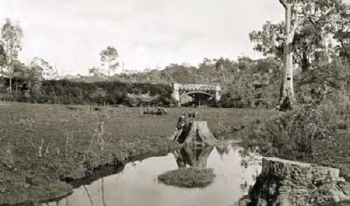
Original Union Bridge, of wooden construction was built in 1871
(this was the first bridge to be built across the upper reaches
of the River Torrens along the course of the Gorge Rad), Cudlee Creek, SA
Replaced with a new bridge in 1916.
Photo Peg & Bill Chartres' collection Circa 1872
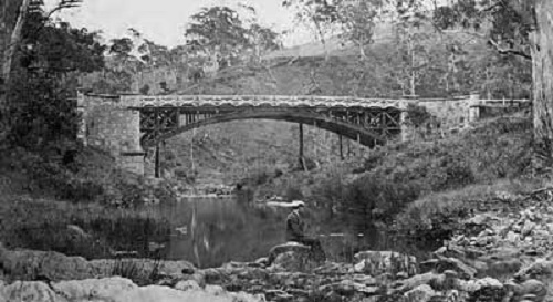
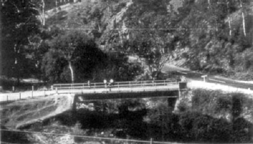
Sixth Creek Bridge (Junction of The Corkscrew and Gorge Road.)
A concrete deck on steel beams constructed in 1913, still in use.
(This photo was taken after the Torrens was in flood)
Photo Peg & Bill Chartres' collection Circa 1916
![Photo Original Blumberg [Birdwood] Bridge](/images/cck70.jpg)
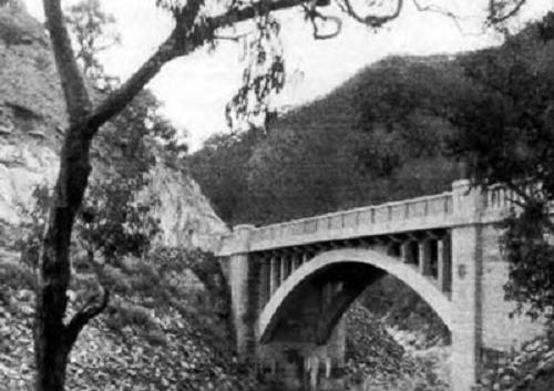
New Blumberg [Birdwood] Bridge, a steel arch,
concrete encased bridge with a span of 50' (15.24m)(built in 1915),
is still in use.
Replaced the original laminated timber arch bridge which was built in 1861.
Photo slsa B19220 Circa 1915
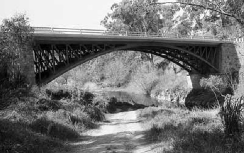
New Union Bridge, span 90' (27.44m) Under construction, Gorge Road,
Cudlee Creek, is still in use (Near the CFS Station).
The original bridge is on the left.
Hollands Creek Road can be seen winding up the hill in the background.
Photo Peg & Bill Chartres' collection Circa 1916
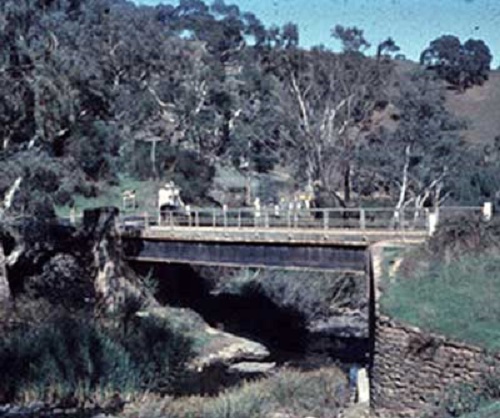
The old Prairie Bridge,
Torrens Hill Road, Cudlee Creek, SA
Replaced by the new Prairie Bridge (1969),
a few hundred metres further east.
Photo slsa B 70224/1 Circa 1963
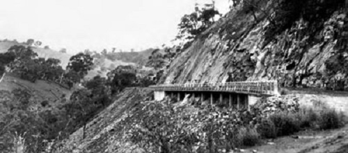
Batchelor's Bridge,span 94' (28.8m), old Gorge Road
Now submerged behind the wall of the Kangaroo Creek Reservoir.
Photo Gumeracha District History Centre
The Cantilever, old Gorge Road, (Although it was named "The Cantilever,
it is not actually a cantilever, it is a concrete slab supported by ten concrete
piers at its outer edge)
about 200' (61m) long,is nearly 34m above the river bed.
Photo Gumeracha District History Centre
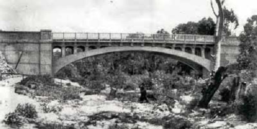
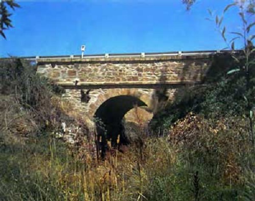
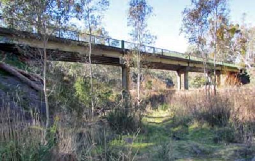
Hoad's Bridge, span 91'3" (27.75m), Gorge Road,
Cudlee Creek is still in use (Near the Cudlee Creek Tavern).
Photo slsa
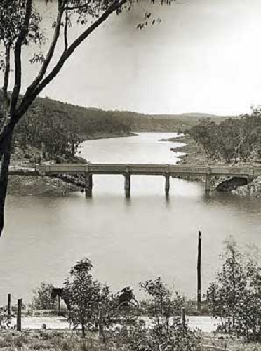
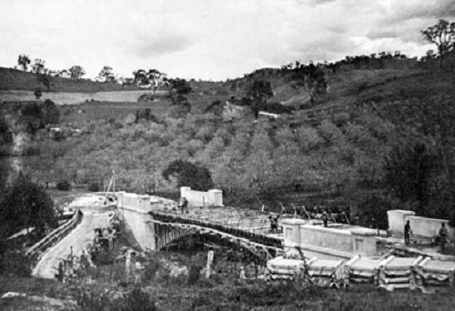
The old Prairie Bridge,Torrens Hill Road, Cudlee Creek, SA. Opened in 1909
Now in the Kangaroo Creek Reservoir.
Once described as one of the finest bridges in South Australia, and at the
time of its completion, was the largest single span reinforced concrete bridge
in the State.
Photo slsa B23800 Circa 1937
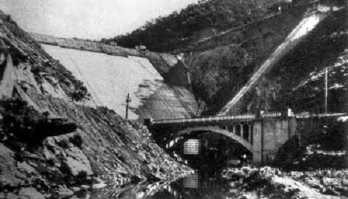
Batchelor's Bridge during the construction
of the Kangaroo Creek Dam,
showing the dam wall.
Now submerged behind the dam wall.
Photo Gumeracha District History Centre Circa 1968
The new Prairie Bridge replaced the original bridge
to Torrens Hill Road during the construction of the Gorge Road deviation
for the Kangaroo Creek Dam (1969).
This is the point where the Gorge Road deviation
rejoins the original Gorge Road..
Photo Gumeracha District History Centre.
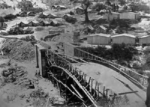
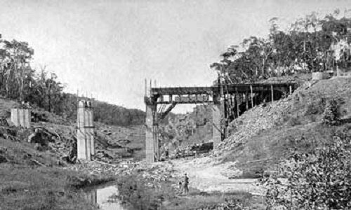
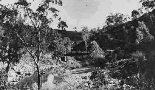
Crouch's Bridge under construction, with the Construction Camp
in the background.
Crouch's Bridge was built near the existing "Crouch's Ford"
crossing the River Torrens,
and is now often submerged when Kangaroo Creek Dam is full.
Photo Transport Services Division, File PN1124 Circa 1921
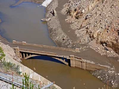
The Old Prairie Bridge, Torrens Hill Road, Cudlee Creek, SA
Replaced by the new Prairie Bridge (1969),
which is a few hundred metres further east.
Circa 1964
Batchelor's Bridge exposed,
during upgrade of Kangaroo Creek Dam 2018.
Photo Peg & Bill Chartres' collection Circa 2018
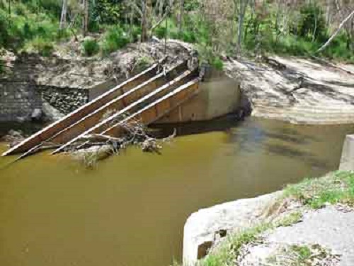
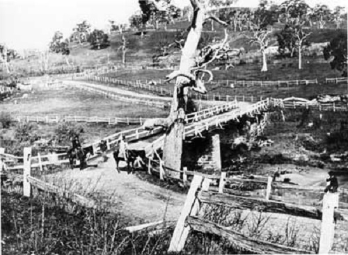
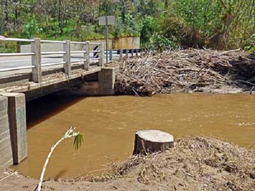
The Old Prairie Bridge, Cudlee Creek, SA
was destroyed during floods in August 1992.
(Photo Dave Scylla Circa 2016)


The following article was sourced from the
TORRENS VALLEY HISTORICAL JOURNAL
November 1982 Number 20
Pages 6 - 15
SOME HISTORICAL NOTES
BEGINNINGS
November 1982 Number 20
Pages 6 - 15
SOME HISTORICAL NOTES
BEGINNINGS
The first recorded public services of Christian Worship in the wider district were held in 1843 in the
store adjoining the barn at Kenton Park on the banks of the Torrens at Gumeracha.
According to the centenary history of Gumeracha, a Primitive Methodist Church was established in the mid
1840s at Hartley Vale which is situated between Kenton Valley and Cudlee Creek. Those responsible for its
establishment included the Kellys and Hannafords who were later associated with the Cudlee Creek church.
Family worship was a feature in many early homes and would have been carried out from the earliest white
settlement in the district. This would probably have led, in various localities, to several families gathering
together in homes for worship together - the origins of many churches.
THE FIRST CHURCH AT CUDLEE CREEK
When the first meetings for public worship at Cudlee Creek were held is not recorded.
The first known record concerning this church is the deed of trust, dated the 19th October 1857, effecting
the transfer from the South Australian Company of a portion of land in section 6096 of the Hundred of Talunga
to trustees.
“Upon trust to erect….a chapel and other conveniences and appurtenances thereto and to hold the same for the performance of Devine Worship and for the service of Almighty God by persons being Protestant ….holding the principles and tenets …. Etc.”
The first Trustees were:
• John Pool
• Warwick Langley
• James Wills Sambell
• Alfred Hoad
• George Hannaford
The first chapel, known as "Cudlee Creek Union Chapel" was probably erected soon afterwards. This was situated at the eastern end of the present cemetery approximately where the iron shed now stands. It stood until the early 1950s. The use of the term 'Union' in the name seems to suggest it was used by Christians of various persuasions. However it was apparently identified with the Mount Torrens Bible Christian circuit from an early period.
EARLY BRANCHES OF THE METHODIST CHURCH
Before 1900 there were several branches of the Methodist church, operating as separate denominations, which have their origins in the movement of Wesley and others in the 18th Century. The three branches which developed in this district were:
Wesleyan Methodist.
The Gumeracha preaching plan of 1899 lists churches or preaching stations at Gumeracha, Kersbrook, Houghton,
Sunning Hill, Hermitage and North Gumeracha.
The chapel at Hartley Vale was first used in the 1840s. It was later used as a school. The Tungkillo Church
was part of the Woodside Primitive Methodist Circuit.
Bible Christian.
The Mount Torrens Circuit included churches at Mount Torrens, Harrogate, Chain of Ponds and Cudlee Creek.
Early Preaching Plans indicate services were also held at Reedy Creek, Rose Hill, Bloomingdale and Monarto
at different times.
These churches came together early in the year 1900 to form a united Methodist Church.
The combined membership of the new Gumeracha and Mount Torrens Circuit was reported at the time to be 236.
In 1913 the circuit was divided into the Gumeracha and the Mount Torrens circuits. in 1955 the Mount Torrens
Circuit and part of the Gumeracha Circuit amalgamated to again form the Gumeracha and Mount Torrens Circuit.
In 1969 the circuit formed a United Parish with the Woodside Methodist circuit and the Lobethal and Woodside
Presbyterian Churches and was named the Eastern Hills United Parish.
Formal union of the Methodist, Presbyterian and Congregational Churches in Australia occurred in 1977.
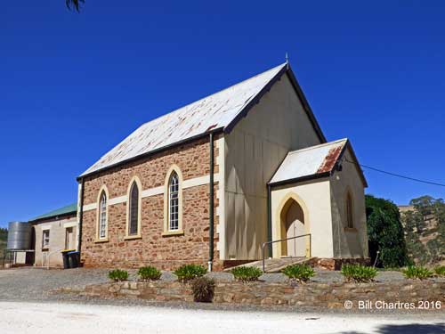
THE "NEW" CHURCH OF 1882
On May 22nd 1881 the trustees, with the Rev. R. Lang in the chair, decided to approach the South Australian
Company to secure a site for a new edifice.
The land (adjoining the original church allotment) was transferred to new trustees, namely,
George Hannaford (the younger) of Foxes Creek
Benjamin Tippett of Cudlee Creek, Farmer
George Kennings of Cudlee Creek, Farmer
Robert Pool of Cudlee Creek, Farmer
The tender by Messers. Kreigier and Schlein for the erection of a new building was accepted in December 1881.
The foundation stone was laid by W. Kelly in January 1882, but owing to many difficulties the opening of the
church did not take place until December 1882. The Bible Christian Magazine of February 1883 describes the
opening meetings:
“Our new church at Cudlee Creek was opened for Devine Worship on December 17 and 18. Dr. Haggar preached
twice on the Sabbath to large congregations. The tea and public meeting the following day were also well
attended. W. Kelly, esq., presided over the latter in his usual happy manner. Addresses were given by
Dr. Haggar, Revs. T. Vercoe, N. Howard and the writer (R. Lang, the minister). Mr J.H. Risely read the report,
which showed the total cost of the building was £428,towards which had been given, in labour and cash
about £328, leaving £100 to be raised by the meeting.
It was not very clear how this was to be done as many in the meeting had already subscribed liberallt.
But in a short time the matter was settled seven or eight persons giving £5 each and the congregation
responding very heartily to the appeal, assisted by friends who resided in other parts of the circuit.
The meeting was quite enthusiastic, having a wholesome dread of debts and an earnest desire that the
Lord’s house should not be encumbered.
The church is 40ft by28, 19ft from floor to ceiling……. We trust and pray that the great end of allplaces of worship and
all preaching may be realised here - the salvation of souls and the Glory of God.”
A complete list of 54 donors to the new building,along with a balance sheet showing a balance in hand of 16 shillings, and 8 pence was published in the Bible Christian Magazine of 1884 along with the report of the first anniversary of the new church.
CHURCH LIFE AND ACTIVITIES
Only an occasional glimpse is available to us of church life in the 19th century.
The following notes have been gleaned from various sources.
The earliest record available at present is a Sunday School roll book. The first entries are undated but are
almost certainly January 1862. The 33 scholars listed on this roll represent the following families: Baker, Banks,
Barty, Botting, Crouch, Daniell(?), French, Hatchard, Hoad, Lambert, Langley, Pool, Redden, Sambell, and others.
The numbers were reduced to about 12-15 within 10 years but in 1899 the Sunday School recorded 7 teachers, 40
scholars, and 500 books in the library.
The first circuit report in November 1867 to the newly established denominational newspaper, the "Bible
Christian Magazine" records the following tantalizing glimpse of a time of particular blessing.
“Mr Ridclift (Pastor) writes to say that about 18 were
hopefully converted during the special services held
at the Chain of Ponds and that at Cudly (spelt as in
the report) Creek the Lord had gloriously revealed his
power in bringing the dead to life. About 20 in this
place profess to have found the pearl of great price.
May He who is able to keep them from falling preserve
them to the end.
The first burial recorded for the Cemetery, which is located on the original church allotment, is that of
David Farnham on February 20, 1867.
Miss Hannaford is often recorded as having "presided at the harmonium" in the early 1880s. The circuit notes
in the November 1889 issue of the "Bible Christian Magazine" mention the "splendid new organ" at Cudlee Creek
which cost £38
A Christian Endeavour Society was formed in about 1892. This was finally discontinued at the end of 1964.
Mrs Murray Chambers, wife of the circuit minister started a Ladies Guild on 27th Sept. 1956 at Cudlee Creek.
The celebrations commenced with a special Service at the Church led by the Minister, Rev D.W. Hancock. The
guest speaker was the Reverend Dr Dean Drayton. The Church sanctuary and the adjoining Sunday School room
were filled for the occasion as many former residents and others returned.
A circuit newspaper, The Methodist Recorder was published monthly around the turn of the century.
Unfortunately only 16 issues between 1898 and 1902 appear to have survived. This quality paper recorded news of the
churches, preaching plans and local business advertisements (which are particularly fascinating).
A similar paper The Salem Messenger was published by the Baptist churches of the district between 1892 and 1913.
More than 60% of issues published have survived.
As there was often considerable interchange between the Baptist and Methodist churches and their members
this paper is also of considerable value to Methodist history.
The strength of the Methodist church from the beginning has been the involvement of its 'lay' men and
women. The church of course is not the building but the people who make up its number. It is unfortunate that in
a sketch of this nature very few of these people can be mentioned. The names of many appear in the records of the
Sunday School, on the tombstones in the cemetery, in the lists of trustees and in the obituaries of some. A few
are recorded in the local church newspapers and in the attractive little booklet which was published for the
1932 Jubilee celebrations. Although the story of most will never be recorded in print everyone who has worshipped,
laboured and served here over the 125 years of the church's history - has played a part in the story of not only the
local church at Cudlee Creek but of the Church universal.
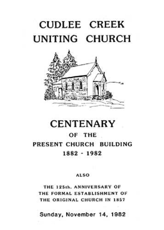
CUDLEE CREEK CHURCH CENTENARY CELEBRATIONS
Sunday, November 14, 1982
The 'Order of Service' handed to folk as they arrived included some brief historical notes on the
church prepared by Alan Phillips. Research had drawn attention to the fact (only days before the celebrations)
that it was not only 100 years since the erection of the present building, but also 125 years since the
formal establishment of the original church in 1857.
The historical notes are reproduced elsewhere in this issue of the journal.
Following the service a luncheon was held in the Cudlee Creek Hall, enabling old acquaintances to be
renewed as guests mixed informally.
A display of historical photographs, papers and Historical Society Journals created considerable interest.
Cudlee Creek's Attractions
Over the years Cudlee Creek has had several important centres for the local community, (and later for tourists)
.
They include The Old Creamery, The Gorge Kiosk, Cudlee Creek Co-operative Cold Store, and The Cudlee Creek Soldiers Memorial Hall.
In later years the The Gorge Wild Life Park (founded in 1965) also become an attraction of the district.
This section is in the very early stage of development, much information is still to be added, Bill.
The Old Creamery
Built in about 1882 as a branch of the Gumeracha Butter Factory, this historic building has had a variety of uses over the years.
When first built it served as a creamery for the many dairies in the area (hence the name), but after a
few years the business declined and the building was vacated.
It was then left unused for some time, until Allen Noble converted
it into a cheese factory.
However this venture was also unsuccessful as the Cudlee Creek District had become primarily a fruit growing district
, and, as the demand for fruit increased, people left the dairy industry in favour of fruit growing.
It again
lay idle until Arthur Rhodes converted it to the districts first General Store.
For many years it served as the General Store, Post Office (circa 1911)and Telephone
Exchange(circa 1915), it was the centre of the community, and was known
as "The Old Creamery" by the locals.
In later years, after the the telephone exchange became automatic, and the Post Office was relocated to the Gorge Kiosk, it became
"The Cudlee Cafe".
Today (2017) "The Cudlee Cafe" is a favourite with locals and tourists for meals and coffee, with a breakfast menu until 12pm,
and a variety of choices all day.
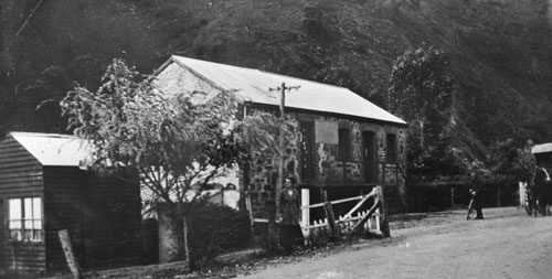
The Creamery, Gorge Road, Cudlee Creek, SA.
Photo Peg & Bill Chartres' collection Circa 1885
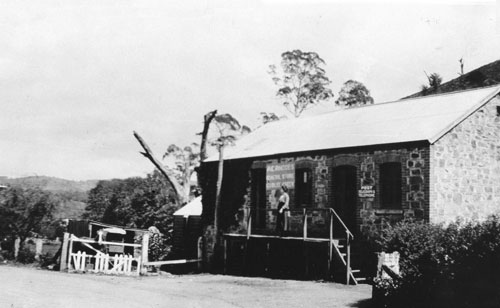
Cudlee Creek General Store.
(Formally The Creamery)
Photo Peg & Bill Chartres' collection - Early 1900's (Date unknown).
Cudlee Creek General Store
(Formally The Creamery)
Photo Peg & Bill Chartres' collection - Early 1900's (Date unknown).
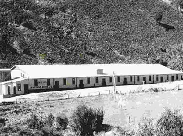
Cudlee Creek Cold Store
(Cudlee Creek Fruit Growers Co-operative Society Ltd.)
At a meeting held in the old church at Cudlee Creek on 28th August 1922 it was decided to build a co-operative
cool store for storage of locally grown fruit. On October 12th a committee of management was elected consisting
of Messrs E. Hannaford (Chairman), E. Pool, F. Tippett, G. Newman, and F. Schultz.
A wooden building consisting of three chambers with a capacity of 15,000 cases and equipped with a 16 ton ammonia
compressor driven by a 47 hp suction gas engine was completed in time for the 1923 apple crop.
In 1925 a packing and grading shed was added and a 32 volt electric generator was installed for lighting
replacing the old kerosene lamps previously used for night work.
In 1938 a mechanical grader, driven by electricity generated by the suction gas engine, was installed.
Previously all the apples were hand graded and sized. In 1940 the capacity of the store was increased to
30,000 cases.
Electric power from Osborne was connected to the store in 1946 enabling the old suction gas engine to be replaced
with electric motors.
The Cudlee Creek Cold Store was the first Co-operative cold store in South Australia.
Cudlee Creek Cold Store, Gorge Road, Cudlee Creek, SA.
Photo Peg & Bill Chartres' collection Circa 1922
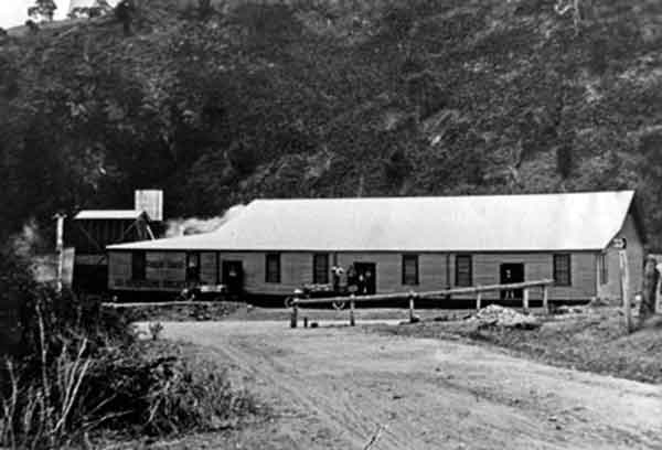
Cudlee Creek Cold Store, Gorge Road, Cudlee Creek, SA.
Photo Peg & Bill Chartres' collection Circa 1940
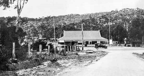
The Gorge Kiosk and Picnic Grounds
(In later years the Kiosk became a tavern and the Picnic Grounds a Caravan Park)
The Gorge Kiosk and Picnic Grounds have been popular with tourists and locals since established in 1924.
Lewis Fisher, opened the kiosk in 1924 and the following article appeared in the The News (Adelaide, SA), Friday
28 November 1924, page 11.
"GORGE ROAD ATTRACTION
Recreation Reserve Popular
One of the ambitions of Mr. L. Fisher, owner of the Gorge Road Kiosk and recreation reserve, is to make the place one of the finest picnic grounds in the State. He has already done much toward that end, and his efforts are being recognised by the motoring public.
Mr. Fisher has performed an excellent service to the community by preserving, for the benefit of the people, the whole of the 10 acres of land which he owns at the Gorge road, near the Cudlee Creek bridge, about 16 miles from Adelaide. The task he has set himself will be expensive, but he is determined to see it tough.
The Gorge road, which was recently, completed by the Government, has already achieved fame in all parts of the Commonwealth for its scenic beauty hundreds of interstate visitors have expressed the opinion that the beauty of the drive along that road is equal to any motor drive in any part of the Commonwealth. Varied mountainous scenery, overhanging moss-covered rocks, and wooded slopes provide a glorious picture for the whole of the drive.
The property owned by Mr. Fisher is the only place available for picnics and recreation, and it is the owner's intention to develop it in the best possible manner. Already he has done much. A fine kiosk measuring 42 ft. by 24 ft. with verandah all round has been erected, and is becoming a popular meeting place for motoring parties. Mr. Fisher intends to build other shade tables on the reserve, and to lay down tennis courts and a cricket pitch for the benefit of visitors. Special parking space will be set aside to accommodate more than 500 cars.
The picnic ground is situated in a beautiful spot. On tee sides the Torrens flows with the hills for a back ground and the Gorge Road provides the frontage.
Mr. Fisher says that he has received so many requests from city business people to convert the place into a residential resort that he intends to build small bungalows for people who desire to spend the week-end there."
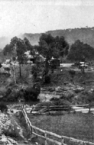
Gorge Kiosk and Picnic Grounds, Gorge Road, Cudlee Creek, SA.
Photo Peg & Bill Chartres' collection Circa 1935
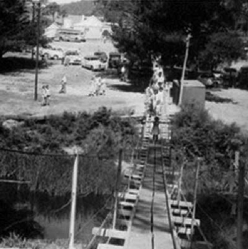
Old Swing Bridge over the River Torrens'
Picnic Grounds, Gorge Road, Cudlee Creek, SA.
Photo Circa 1959
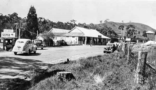
Gorge Kiosk and Picnic Grounds, Gorge Road, Cudlee Creek, SA.
Photo Peg & Bill Chartres' collection Circa 1940
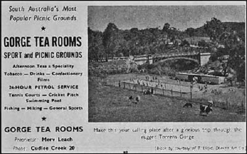
Add for the Tea Rooms (Gorge Kiosk), Gorge Road, Cudlee Creek, SA.
Circa 1950's
Gorge Kiosk, Gorge Road, Cudlee Creek, SA (1937).
Photo slsa B 23802 Circa 1937
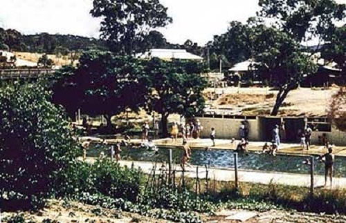
Gorge Kiosk, Swimming Pool
The Swimming Pool was opened by the Premier (T. Playford) December 1939.
The photo on the left is the approximate location of where the pool was built..
Photo Doug Tilley Circa Late 1950's
(The swimming pool was destroyed by floods in 1992 and was not rebuilt.)
The early proprietors of the Gorge Kiosk / Picnic Grounds
Lewis Fisher, opened the kiosk and picnic grounds in 1924
1924-1927 –-- L. Fisher1928--1936 --- Davies Ltd.
1937-1949 –-- L. Lambert
1950 – 1958 --- M.J. & M.S.C. Leach
1959 to 1960 --- Floyd & Bament
1962 – 1970 --- A. & H. Hartman
?? - ?? --- ??Kandelaars
?? - ?? --- B. & M. Childs & G. & D. ??
????????
If anyone can help me with any information here I would appreciate it, (
Email Bill), thanks Bill
THE CUDLEE CREEK SOLDIERS MEMORIAL HALL
The hall was opened on 17 November 1956 by R.G.HANNAFORD, and is community owned,
managed and maintained.
It was built with the support of the local community who had held many fund raisers
and helped with the construction.
The community planted trees around the hall in recognition of the local servicemen who
served in WW2.
Over the years is it has been the centre of the local community's entertainment,
providing balls, dances, concerts, table tennis, community and school functions and
Christmas events.
In 2020, following the Sampson Flat and Cudlee Creek Bushfires, the hall received a
$25,000 grant from Community Bushfire Grants which enabled renovations including a
new roof, solar panels, a repaint and a new stage curtain.
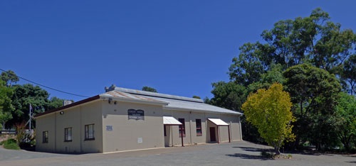
Cudlee creek Soldiers Memorial Hall 2016
Cudlee Creek Soldiers Memorial Hall was
erected as a tribute to those who served
in the various conflicts in which Australia
was involved.
(Photo (©) - Peg & Bill Chartres' collection - circa 2016)
Chronicle (Adelaide), 27 November 1947.
Between 200 and 300 past and present
residents of the Cudlee Creek district
were at the local co-operative cold
store last Friday to hear the Premier
(Mr. Playford) officially open the
Back to Cudlee Creek celebrations.
Mr. Playford, who was accompanied by
Mrs. Playford and Mr. McBride, MHR,
and who was introduced by the chairman
of the celebrations committee
(Mr O. J.Sickerdick), congratulated the
district on its achievements.
Introducing the Premier, Mr. Sickerdick
said that the main purpose of the
celebrations was to raise money for the
erection of a soldiers' memorial hall.
Keith Menz (Peg's father) was one of many
locals who assisted with the building
of the hall.
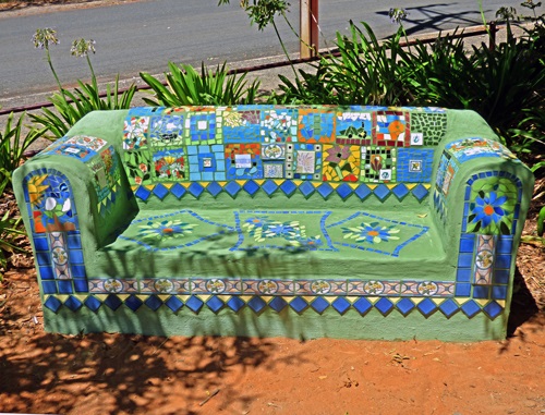
The Community Mosaic Couch project
brought together locals in bush-fire
affected communities in the Northern
Adelaide Hills to make mosaic patches
that joined to form 'quilts' to adorn
a trail of outdoor community couches.
This couch is in the Public playground
behind the Cudlee Creek
Soldiers Memorial Hall.
(Photo (©) - Peg & Bill Chartres' collection - circa 2016)
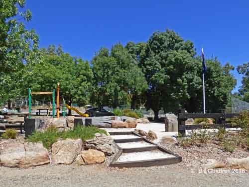
Public playground behind the
Cudlee Creek Soldiers Memorial Hall.
(Photo (©) - Peg & Bill Chartres' collection - circa 2016)
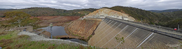
Kangaroo Creek Dam
The Kangaroo Creek Dam was first proposed in 1916
(Advertiser, Friday 21 July 1916, page 6)
THE NEW TORRENS GORGE-ROAD.
This morning the Commissioner of Public Works (Hon. H. Jackson) will make an inspection of the route of the new road
from the Torrens Gorge to Chain of Ponds, in view of a diversion proposed by Mr. Stevens, the Engineer for Roads and
Bridges, to provide for a water conservation scheme being carried out without involving a deviation of the costly road.
Since the road was put in hand, about a year ago, it has been proposed to construct a dam across the Torrens, about
four miles above the Gorge Weir, to regulate the flow of water thence to the place where it empties itself on the
flat country and finally enters the Port River.
It is claimed by the authorities that if a large weir were built at the spot indicated, known as Kangaroo Creek
Junction, it would hold back a great deal of flood waters which could in
the summer be released into the watercourse as desired, so that the gardeners and orchardists between the hills and
the city would have supplies to pump from the river. At comparatively little expense the work could be carried out,
and in addition to acting as a reserve reservoir for drawing on in times of scarcity the engineers say it would have
the effect of preventing the flooding of land near the mouth of the river, which is gradually becoming thickly
populated.
(Advertiser, Thursday 3 February 1916, page 6)
... Now, however, there is a proposal to construct another weir in the Torrens Gorge, for the benefit of gardeners
on the high and low levels of the river. This weir would raise the surface of the water about 100 ft., and if it
is built the road will have to be regraded and taken up another 100 ft. in that part. ...
However this weir was never constructed despite the Gorge Road plan being realigned to allow for it. The Gorge
Road construction began in 1912 - 1914 when the section from the Gorge Weir (near Athelstone) to Castambul was
completed, however the section Castambul to the Gumeracha Bridge was not completed until 1924.
In 1962 a submission was made to the Public Works Committee for a much larger dam (Capacity: 24,400 megalitres) to
be built at Kangaroo Creek which required a deviation of the Gorge Road to be built and the construction of two
new bridges (Playford Bridge near Castambul and the New Prairie Bridge near
Torrens Hill).
Construction of the Kangaroo Creek dam began in 1966 and was completed in 1969. The Reservoir is a 24,400 megalitre
artificial water storage facility in the Adelaide Hills, South Australia. It was built by damming the River Torrens
west of Cudlee Creek, near its junction with Kangaroo Creek (hence its name)
.
The dam consists of a 131m long, 65m high concrete clad, rock filled dam wall and the stored water is used to
maintain the Hope Valley Reservoir's level by discharging water into the River Torrens, which then flows into Hope
Valley Reservoir via a pipeline beginning at the Gorge weir, Athelstone.
The water level of Kangaroo Creek Dam can be topped up by water from the River Murray which is discharged from the
Millbrook Reservoir into the River Torrens at Cudlee Creek.
The Kangaroo Creek reservoir was opened by The Hon. R. Steel Hall, M.P., Premier of South Australia, on Friday
5th December 1969.
In 1982, following the River Torrens Flood Mitigation Study (EWS, 1980) report the dam wall and spillway
were modified to pass a flood with a return period of 50,000 years. The modifications involved raising the height
of the dam and the top of the spillway by 2.75 metres and inserting into the wall of the spillway two outlet ducts
each 4 metres wide by 3 metres high.
Although the height of the dam and spillway were raised, the ducts give a lower overflow level, and storage of
the reservoir was reduced from 24,400 Ml to 19,160 Ml and the overflow frequency increased.
The purpose of Kangaroo Creek reservoir was to increase the storage capacity for River Torrens from 4,500 million
gallons to approx. 10,500 million gallons.
The reservoir area controls 112 sq miles of the River Torrens catchment (which also feeds the
Millbrook Reservoir) and the area of water spread equals 103 hectares.
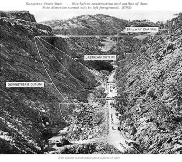
The Kangaroo Creek Dam submerged 3 Bridges on the old Gorge Road,:-
Batchelor's Bridge (located just behind the dam wall),
Crouch's Bridge (located further east, between the dam wall and Torrens Hill),
and Prairie Bridge (located still further east, just below Torrens Hill).
SA Water Photos of the construction of the
KANGAROO CREEK DAM
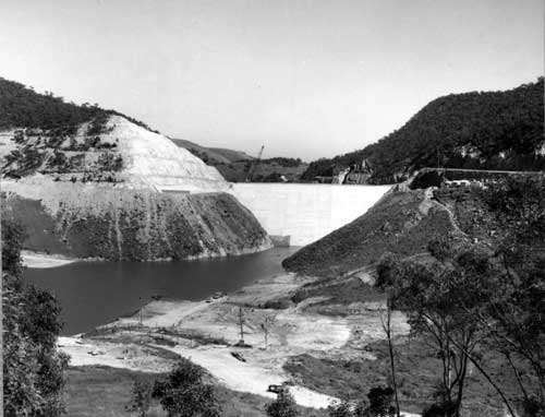
Reservoir area 1969,
as the Dam Wall nears completion.
(Photo - SA Water September 1969 - Reservoir area - Book169 image830)
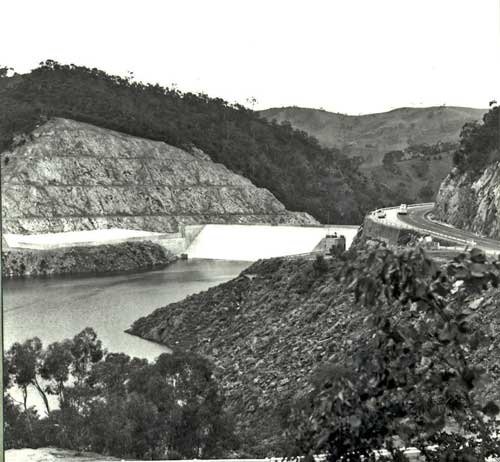
Reservoir area 1970,
with the new Gorge Road deviation on the right.
(Photo - SA Water September 1970 - Book169 image920)
Dam Wall 1969,
showing the Dam Wall Face with Batchelor's Bridge in the foreground.
(Photo - SA Water September 1969 – Concrete face - Book169 image755)
Cleaning out settling pond 1969,
showing the Damm Wall Face before the concrete cladding
and Batchelor's Bridge in the background.
(Photo - SA Water April 1969 – Cleaning out U/S settling pond - Book168 image550)
Access ramp to intake structure 1968,
under Batchelor's Bridge.
(Photo - SA Water December 1968 – Access ramp to intake structure - Book168 image336)
Dam embankment 1969,
viewed from above the Spillway.
(Photo - SA Water August 1969 - Dam embankment - Book169 image814)
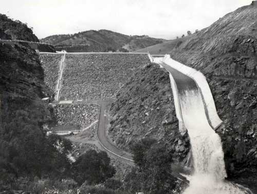
First Spillway overflow 1971,
showing the completed Dam Wall on the left.
(Photo - SA Water August 1971 – first overflow - Book169 image947)
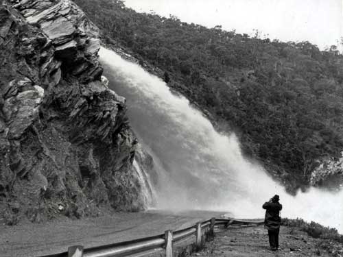
First Spillway overflow 1971,
discharging over the old Gorge Road.
(Photo - SA Water August 1971 – first overflow - Book169 image952)
No. 37 December 1990
"Gumeracha District—A Vital Link in the Metropolitan Adelaide Water Supply"
Kangaroo Creek Dam
 The most recent development in the scheme was the construction of Kangaroo
Creek Dam. Following a series of floods which resulted in considerable property
damage, public demands for remedial action became ever stronger. In 1925 [This
proposal was actually made in 1916], the then Engineer-in-Chief proposed flood mitigation works
on the River Torrens which included a regulating dam to be located either two miles below Birdwood or at
Kangaroo Creekl. The former site proved to be too far upstream to command a large
enough catchment and so the Kangaroo Creek site became the final choice, although
matters did not proceed at that time.
The most recent development in the scheme was the construction of Kangaroo
Creek Dam. Following a series of floods which resulted in considerable property
damage, public demands for remedial action became ever stronger. In 1925 [This
proposal was actually made in 1916], the then Engineer-in-Chief proposed flood mitigation works
on the River Torrens which included a regulating dam to be located either two miles below Birdwood or at
Kangaroo Creekl. The former site proved to be too far upstream to command a large
enough catchment and so the Kangaroo Creek site became the final choice, although
matters did not proceed at that time.
With a growing demand for water in the mid 1950's, the proposal was again put
forward and in 1962 a submission was made to the Public Works Committee to
construct the dam. Initially a concrete arch dam was proposed for the site but after
further study of the abutment geology, this was abandoned in favour of a rock-fill
dam2.
Work on the diversion tunnel was started in August 1966. Work on the dam proper
commenced in January 1968 and was completed in October, 1969. The reservoir
began to fill in September 1969 and the dam was officially opened on the 5th
December, 1969 by the Premier of South Australia, the Honourable R. Steele Hall3.
Originally, the dam was designed to withstand floods with a return period of 10,000
years. Further analysis of flood frequency, carried out as part of the River Torrens
Flood Mitigation Study (EWS, 1980) revealed that the dam would only withstand a
flood with a return period of 500 years. The study recommended that the dam and
spillway be modified to pass a flood with a return period of 50,000 years4.
The modifications involved raising the crest of the dam and the top of the spillway
by 2.75 metres and inserting into the wall of the spillway two outlet ducts, 4 metres
wide by 3 metres high. Although the height of the dam and spillway was raised, the
ducts give a lower overflow level than previously. Full supply storage of the reservoir
will thus be reduced from 24,400 Ml to 19,160 Ml r I overflow frequency will be
increased slightly from the previous 2.5 years5.
1 Smith, C.L. and Twidale, C.R., An Historical Account of Flooding and Related Events in the Torrens
River System, Vol.3.
2 EWS, Kangaroo Creek Dam—Historical Account of Construction and Operations.
3 Ibid.
4 EWS 1981, River Torrens Flood Mitigation Study Technical Report No. 4—Probable Maximum
Torrens Valley Historical Journal - Number 36 21
5 Department of Environment and Planning 1981, Assessment of the Environmental Impact of the River
Torrens Flood Mitigation Study Proposed by the S.A. Engineering and Water Supply Department.
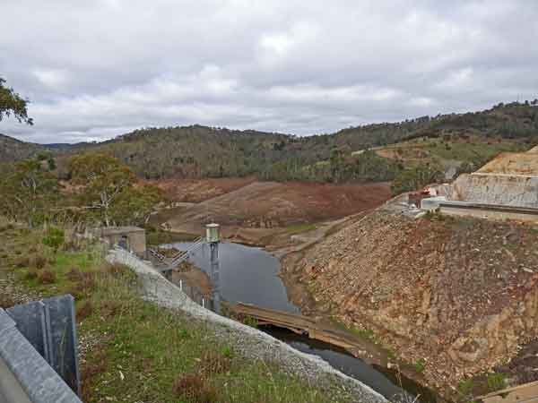
Kangaroo Creek Dam Upgrade
SA Water upgraded Kangaroo Creek Dam further 2015 t0 2019.
This upgrade ensured the dam complied with ANCOLD (Australian National Committee on Large Dams) standards.
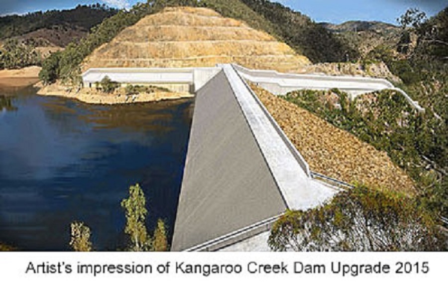
Construction began in late 2015, and was completed in November 2019.
The work widened the spillway, raised the wall and strengthened the wall and will
help manage major floods and
increased the dam's ability to withstand earthquakes
however it did not increase the dam’s capacity, as the spillway height remained
unchanged.
Contractor Bardavcol Pty Ltd
Contract Value $78,513,994
Completion Date September 2018
Project Description
Major safety upgrade to the existing concrete lined rock fill dam to meet
ANCOLD requirements
Excavation of 300,000m3 of rock to widen the spillway by up to 40m
Extension of the outlet tunnel and pipe work by approximately 50m
Buttressing of the existing rock fill embankment (200,000m3)
Raising of the embankment crest including extension of the concrete face slab
using slip form techniques
Significant concrete works (32,000m3) to line the spillway including temperature
sensitive mass pours and ogee crest construction
Construction of post tensioned anchors to the existing ogee crest
Electrical, SCADA and security works
On March 15th 2018 SA Water posted on FaceBook
"As part of a major safety upgrade at the Kangaroo Creek Dam in the Adelaide Hills,
we've gradually been
lowering the dam's water level.
It's currently at around two per cent of capacity and you can just start to see the top of the usually
underwater Batchelor's Bridge. The bridge was built in the 1920s before the dam was constructed.
We expect to completely empty the dam by the end of this month, so our contractor can begin work on a
10,500 square metre concrete slab on the upstream face of the embankment.
Work on this overall project began in early 2016 and is expected to be complete in late 2019."
Batchelor's Bridge Partly exposed
(Photo - SA Water - March 2018)
Photos of the progress.
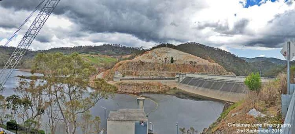
Kangaroo Creek Dam - 2nd September 2016
The hillside west of the dam wall being cut way to widen the spillway.
(Photo (©) - Peg & Bill Chartres' collection - circa 2016)
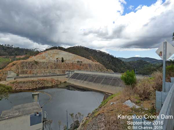
Kangaroo Creek Dam - September 2016
Excavation under way to remove 300,000m3 of rock
to widen the spillway by up to 40m
(Photo (©) - Peg & Bill Chartres' collection - circa 2016)
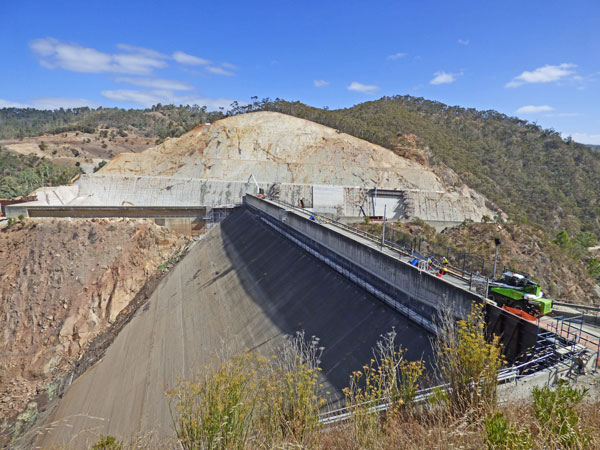
Kangaroo Creek Dam - 20th March 2018
Working on the widening of the spillway.
(Photo (©) - Peg & Bill Chartres' collection - circa 2018)
Kangaroo Creek Dam - 20th May 2018
Working on the widening of the spillway.
(Photo (©) - Peg & Bill Chartres' collection - circa 2018)
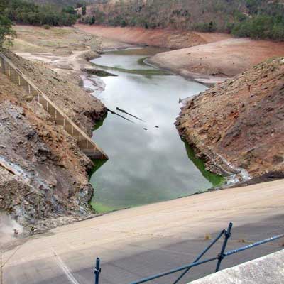
Kangaroo Creek Dam - 20th May 2018, Batchelor's Bridge exposed.
(Photo (©) - Peg & Bill Chartres' collection - circa 2018)
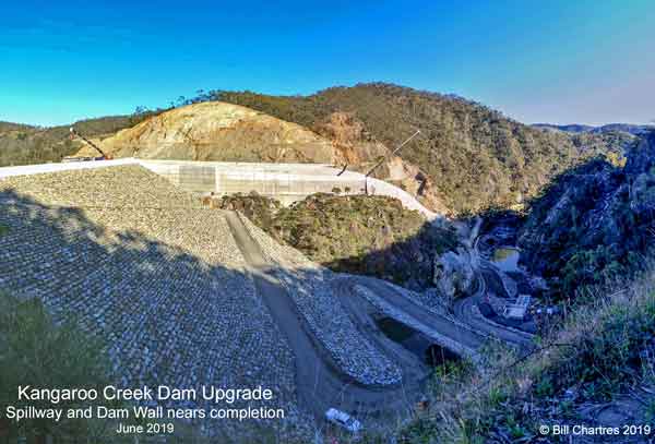
Kangaroo Creek Dam - 26th June 2019
Work on the widening of the spillway and strengthening
of the embankment nears completion.
(Photo (©) - Peg & Bill Chartres' collection - circa 2019)
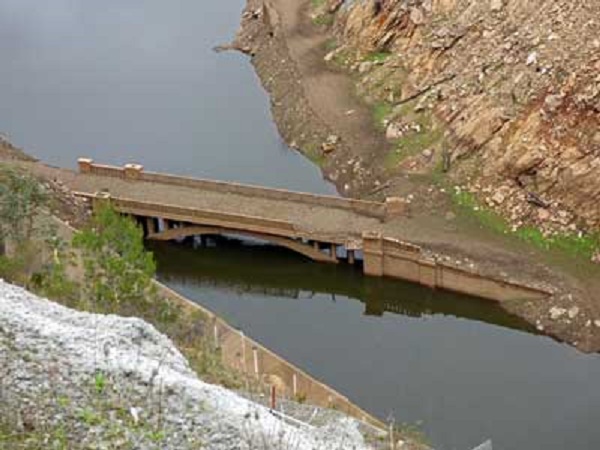
Kangaroo Creek Dam - 20th May 2018, Batchelor's Bridge exposed.
(Photo (©) - Peg & Bill Chartres' collection - circa 2018)
Kangaroo Creek Dam - 26th June 2019
Work on the widening of the spillway and strengthening
of the embankment nears completion.
(Photo (©) - Peg & Bill Chartres' collection - circa 2019)
The Gorge Road Today
On July 11th 2017 Weekend Notes
published an article on the
Gorge Road as it is today (2017)
by Michael Genrich.
View his article Here. --
Gorge Road article
Then click back in your browser to return to this page.